During the three weeks we're in Baja we'll travel more than 700 miles south of the border. We'll be traveling in large vans making frequent stops for roadside rambles, both for lectures and observations of the landscape and the towns. In general, we will not be in places where we can be reached, however, there are internet cafes in several of the towns we visit, so we will have intermittant access to email.
Here is our itinerary, as we have planned it. We will be in these loctions more-or-less on the days listed. I've included a notation next to the towns we know have internet access, and a link to more informtion about each of our different stops.
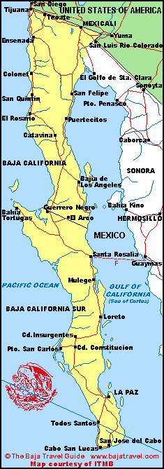
Use the map to see where we are as we travel around Baja.
Jan 3 Camp in Colonia Vicente Guerrero near San Quintin. Here's the weather forcast for San Quintin.
Jan 4 San Quintin to Catavina. Weather for Catavina.
Jan 5 Catavina to Bahia de los Angeles. Our home base throughout the program is the Vermilion Sea Field Station (internet) Weather for Bahia de los Angeles.
Jan 7 Bahia de los Angeles to San Ignacio (internet two years ago, not last year, so...), traveling through Guerrero Negro (and enjoying a legendary almuerzo de tacos pescado at Tacos Henry!). Weather for San Ignacio.
Jan 9 San Ignacio to El Coyote on Bahia de la Concepcion, with stops in Santa Rosalia and Mulege. Bahia de la Concepcion is the bay just south of Mulege. Here's the Mulege area weather.
Jan 11 Bahia Concepcion to Mulege (internet)
Jan 13 Mulege to Guerrero Negro and Scammons Lagoon. Weather for Guerrero Negro.
Jan 14 Guerrero Negro to Bahia Los Angeles
Jan 21 Bahia Los Angeles to Biola
Note that these dates are subject to change due to variables such as weather, fuel supply, and road and sea conditions over which we have no control. But that's a life lesson in itself....